Adding Value During Delay
Don’t Waste the Wait: How the Smart Use of Geoscience Can Keep Offshore Wind Projects Moving
by Dan Sumner
When Progress Pauses
Offshore wind is growing fast. Around the world, governments and developers are racing to bring new projects online. But building a wind farm at sea is a complex, multi-year endeavour and progress doesn’t always follow the plan.
Delays can happen for many reasons: regulatory changes, grid connection hurdles, evolving ownership structures, or shifts in how projects plan to sell their power. One of the first areas to be affected is often the survey campaign, the critical geoscience work that maps the seabed and underpins many major design and project decisions.
But when projects are delayed, or priorities shift, what can be done to keep momentum going? Often there is untapped value in the data you already have. Strategic geoscience consulting during these pauses can keep projects moving, reduce risk, and help unlock better decisions without waiting for the next vessel mobilisation.

What Can You Do With the Data You Already Have?
Most offshore projects begin with a wealth of untapped information. Public data and even legacy studies often sit idle while teams wait for new acquisition.
A smart pivot is to shift focus from collecting new data to extracting more value from what you already have. With the right geoscience expertise, early-stage interpretation, reprocessing, and modelling can deliver major insights and real project value.
Making the Most of Public Data at Concept Stage
At the earliest phase of an offshore wind project before any survey vessels are mobilised there is often a surprising amount that can be learned from public and open-access data. These early insights help developers form a clearer picture of both opportunity and risk, even in the absence of site-specific measurements.
Valuable information can be found in a range of publicly available sources. Admiralty and marine navigation charts offer a basic overview, while satellite derived bathymetry and regional seabed maps provide broad context on underwater terrain. National geological surveys typically maintain archives of historic borehole records, which can offer hints about sub-seabed geology. Academic literature and past industry studies also contribute important interpretations and precedent of the geomorphological processes that led to the current site conditions. Meanwhile, public metocean datasets covering wind, wave, and current regimes give an early sense of environmental forces at play.
With careful interpretation, these datasets can support a range of practical early-stage tasks. Developers can begin mapping constraints. Potential geohazards, such as shallow gas pockets or areas prone to slope instability, can be flagged. Preliminary assessments of unexploded ordnance (UXO) risk can help shape future mitigation strategies. Cable corridors and landfall options can be broadly planned, and an outline survey strategy can be developed to guide data acquisition once timelines permit. These items all have an impact and lead into potential high-level modelling of levelised cost of energy (LCoE), offering a rough benchmark for project economics.
This early phase is not about absolute precision, but it is about direction. By using freely available data well, developers can lay a stronger foundation for smarter, faster decisions later on.
Adding Value After Initial Surveys
Even limited reconnaissance surveys such as multibeam sonar, shallow seismic, or a handful of cone penetration tests (CPTs) can be leveraged to advance design and reduce risk when project timelines are paused.
Reprocessing and Re-interpretation
Data that has been already acquired can often yield new insights. Independent review or reprocessing can spotlight areas of interest and enhance data quality. Advanced seismic processing techniques, if applicable, can sharpen the resolution of subsurface features.
Building Preliminary Ground Models
With even sparse data, it’s possible to create early 3D ground models. These help in the understanding of the range of possible soil conditions, geological domains, and variability, laying the groundwork for design assumptions.

Localised Geohazard Studies
If certain areas show potential risks, targeted studies can be undertaken even during a delay. For example, slope stability assessments or assessments of scour potential can be conducted using available bathymetric and metocean data.
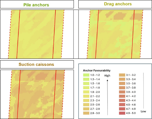
Synthetic CPTs and Early Foundation Feasibility
There is a growing uptake of the use of machine learning and empirical techniques to estimate geotechnical behaviour from geophysical data, producing what are known as “synthetic CPTs”. At this point in time, these tools help to define zones of uncertainty and guide where future ground truthing is most needed.
Using these ground property predictions, developers can begin to screen different foundation concepts based on inferred ground conditions.
Turn Delay into Advantage with OWC
Delays are a part of offshore wind development. But they don’t have to be a dead zone for progress.
With the right geoscience consulting approach delivered by a dedicated team at OWC, a pause can become productivity to generate insights, advance designs, and reduce future risk. Making the most of the data you already have is the best way to ensure site characterisation progress.
Whether you’re exploring methods to turn downtime into design progress, or are curious to discover how strategic geoscience consulting can keep your offshore wind projects moving even when the vessels aren’t, connect with Dan Sumner.
Connect with The Expert

Dan Sumner
Senior Consultant, Geoscience Package Management